What is happening?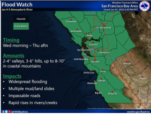
Another storm front is headed to the Bay Area that will bring substantial rainfall on Wednesday and continuing Thursday, not tapering off until Thursday afternoon.
National Weather Service has issued the following advisories:
- Flood Watch in effect from 4:00AM Wednesday, January 4 through 4:00PM January 5.
- High Wind Watch in effect from 4:00AM Wednesday, January 4 through 10:00PM January 5.
What could this mean for Marin residents?
- Localized flooding will occur in low-lying areas or where storm drains or drainage systems are temporarily blocked by debris.
- Flooded roadways especially in low-lying or flood prone areas, like Marin City or Tam Junction, or where debris flow
- Slick roadways.
- Slides (mud / debris) in areas with steep hillsides.
- High stream/creek levels, possibly reading flood stage in some areas of the County.
- Strong gusty winds could blow around unsecured objects and blow down tree limbs.
- Power outages may result from strong winds and rain.
What actions can I take to prepare and/or stay safe?
Before the storm
- Secure outdoor objects that could be blown over by wind (e.g, patio furniture, sports equipment, trash cans, pop-up canopies)
- Rake leaves and other yard debris and place in green bin (to keep out of gutters and storm drains)
- Make sure your emergency kit is up-to-date: have a flashlight, radio and spare batteries handy if the power goes out.
- Protect homes and businesses in low-lying flood-prone areas by making sandbags.
- Mariners / Houseboat occupants should secure vessel for severe wind and seas
- Sign up to receive AlertMarin emergency calls, text message or email alerts.
- Discuss with your employer about – where possible — a work from home option during the storm, especially if you live in a low-lying area where roadways flood and can keep you from returning home.
- Visit Emergency.MarinCounty.org for additional resources for preparing for a storm.
During the storm
- Avoid unnecessary travel. Strong winds and wet roads make travel risky, and possible flooding may prevent you from returning home. Staying home is the safest option until the storm passes. If its an emergency, allow emergency responders to come to you.
- Use extra caution when driving. If you MUST leave your home, drive carefully: slow down, keep both hands on steering wheel, turn on head lights, allow extra space between vehicles, and watch for downed tree branches, trees, and powerlines. Allow extra time in case of detours away from flooded roadways.
- Do not walk or drive around barricades or through standing water. Turn around, do not drown. If it’s an emergency, allow emergency responders to come to you.
- Stay away from downed power lines. Always assume a fallen power line is live and do not touch it with your hand or other object. Call 9-1-1 immediately to report the fallen line.
- Mariners / Houseboats should remain in port. Strong winds and cause hazardous seas which could capsize or damage vessels.
- Monitor Emergency.MarinCounty.org for the most up-to-date weather and emergency information.
Sandbags
Sand, bags, and shovels are available for Fairfax residents at the Skate Park (Pavilion Parking Lot).
Remember that Emergency.MarinCounty.org is the go-to resident resource for emergency information throughout this storm event.